Fill Out Your Ifr Navigation Log Form
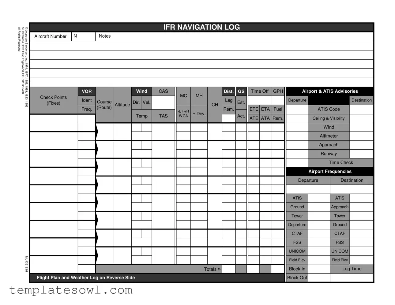
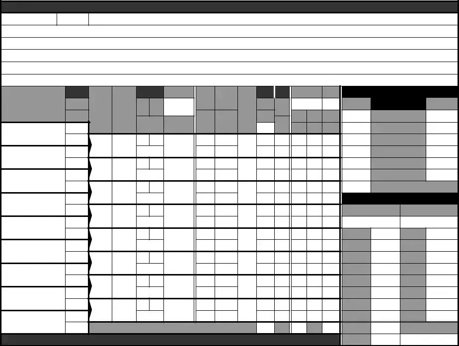
The IFR Navigation Log form serves as a foundational tool for pilots navigating the complexities of instrument flight rules. Designed to encapsulate critical flight information, the form meticulously organizes data pertaining to aircraft specifications, departure and destination details, and crucial navigational parameters. Within its structured layout, users find designated spaces to enter aircraft identification numbers, wind conditions, course headings, and planned altitudes. Moreover, it requests the inclusion of vital airport advisories and en route checkpoints, ensuring that pilots maintain awareness of potential hazards. As flight planning demands precision, the form includes sections for weather logging, enabling pilots to record both reported and forecasted conditions, such as ceiling and visibility. Essential for safe flight operations, it also prompts the pilot to delineate their fuel status and allocate alternative airports should unforeseen changes arise. Regulatory compliance is reinforced through its requirement for logging estimated times en route and arrival, while also accommodating special equipment notations. Ultimately, the IFR Navigation Log stands as a testament to meticulous aviation planning, serving both as a record and a guide throughout the journey.
Ifr Navigation Log Example
AllRightsReserved |
55InvernessDriveEast, |
©JeppesenSanderson, |
|
|
|
|
|
IFR NAVIGATION LOG |
|
|
|
|
|
|||
Aircraft Number |
N |
Notes |
|
|
|
|
|
|
|
|
|
|
|
|||
|
|
|
|
|
|
|
|
|
|
|
|
|
|
|||
|
Englewood, CO |
Inc. 1974, 1977, |
|
|
|
|
|
|
|
|
|
|
|
|
|
|
|
1982, 1989,1993, |
|
VOR |
|
|
Wind |
CAS |
|
Dist. |
GS |
Time Off |
GPH |
Airport & ATIS Advisories |
|||
|
|
|
|
|
|
|
||||||||||
|
|
|
Check Points |
|
|
|
|
|
MC |
MH |
|
|
|
|
|
|
|
|
|
Ident |
|
|
|
|
|
Leg |
|
|
|
Departure |
|
Destination |
|
|
|
1996 |
(Fixes) |
Course |
|
Dir. Vel. |
|
|
Est. |
|
|
|
||||
|
|
|
Altitude |
|
|
CH |
|
|
|
|
|
|||||
|
|
|
Freq. |
(Route) |
|
|
|
|
ETE ETA |
Fuel |
|
ATIS Code |
||||
|
|
|
|
|
|
|
|
Rem. |
|
|
||||||
|
|
|
|
|
|
|
|
|
± Dev. |
|
|
|
|
|
|
|
|
|
|
|
|
|
|
Temp |
TAS |
WCA |
Act. |
|
|
|
|
|
|
|
|
|
|
|
|
|
|
ATE ATA Rem. |
|
Ceiling & Visibility |
||||||
|
|
|
|
|
|
|
|
|
|
|
|
|
||||
|
|
|
|
|
|
|
|
|
|
|
|
|
|
|
|
Wind |
|
|
|
|
|
|
|
|
|
|
|
|
|
|
|
|
Altimeter |
|
|
|
|
|
|
|
|
|
|
|
|
|
|
|
|
Approach |
|
|
|
|
|
|
|
|
|
|
|
|
|
|
|
|
Runway |
|
|
|
|
|
|
|
|
|
|
|
|
|
|
|
|
Time Check |
|
|
|
|
|
|
|
|
|
|
|
|
|
|
|
Airport Frequencies |
|
|
|
|
|
|
|
|
|
|
|
|
|
|
|
Departure |
Destination |
|
|
|
|
|
|
|
|
|
|
|
|
|
|
|
ATIS |
|
ATIS |
|
|
|
|
|
|
|
|
|
|
|
|
|
|
Ground |
|
Approach |
|
|
|
|
|
|
|
|
|
|
|
|
|
|
Tower |
|
Tower |
|
|
|
|
|
|
|
|
|
|
|
|
|
|
Departure |
|
Ground |
|
|
|
|
|
|
|
|
|
|
|
|
|
|
CTAF |
|
CTAF |
|
|
|
|
|
|
|
|
|
|
|
|
|
|
FSS |
|
FSS |
|
|
MU436183H |
|
|
|
|
|
|
|
|
|
|
|
UNICOM |
|
UNICOM |
|
|
|
|
|
|
|
|
|
Totals » |
|
|
|
Block In |
|
Log Time |
|
|
|
|
|
|
|
|
|
|
|
|
|
|
|
Field Elev |
|
Field Elev |
|
|
|
Flight Plan and Weather Log on Reverse Side |
|
|
|
|
|
|
Block Out |
|
|
||||
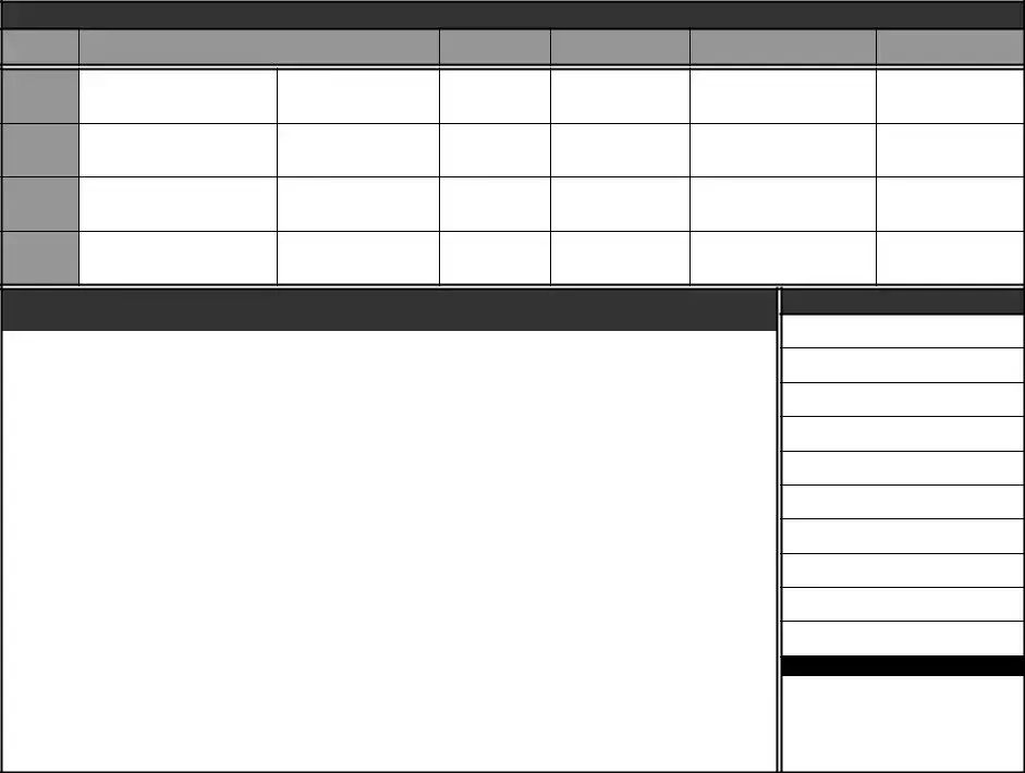
WEATHER LOG
Ceiling, Visibility and Precipitation
Reported |
Forecast |
|
|
Winds Aloft
Icing
and Freezing Level
Turbulence
and Cloud Tops
Position of Fronts,
Lows and Highs
Departure
Enroute
Destination
Alternate
FLIGHT PLAN
|
1. |
Type |
2. Aircraft |
3. Aircraft Type/ |
|
4. True |
5. Departure |
6. Departure Time |
7.Cruising |
|
|||
|
|
VFR |
Identification |
Special Equipment |
Airspeed |
Point |
|
Proposed (Z) |
Actual (Z) |
Altitude |
|
||
|
|
IFR |
|
|
|
|
|
|
|
|
|
|
|
|
|
DVFR |
|
|
|
|
Knots |
|
|
|
|
|
|
|
|
|
|
|
|
|
|
|
|
|
|
|
|
|
8. Route of Flight |
|
|
|
|
|
|
|
|
|
|
||
|
|
|
|
|
|
|
|
|
|
|
|
|
|
|
9. Destination (Name of airport and city) |
10. Est. Time Enroute |
11. Remarks |
|
|
|
|||||||
|
|
|
|
|
Hours |
|
Minutes |
|
|
|
|
|
|
|
|
|
|
|
|
|
|
|
|
|
|
|
|
|
|
12. Fuel on board |
13. Alternate Airport(s) |
|
14. Pilot's Name, Address, Tel # & Aircraft Home Base |
15. # Aboard |
|||||||
|
Hours |
Minutes |
|
|
|
|
|
|
|
|
|
|
|
|
|
|
|
|
|
|
|
|
|
|
|
|
|
|
16. Color of Aircraft |
|
|
17. Destination Contact / Telephone (Optional) |
|
|
|||||||
|
|
|
|
|
|
|
|
|
|
|
|
|
|
|
|
|
CLOSE VFR FLIGHT PLAN WITH _____________________ FSS ON ARRIVAL |
|
|||||||||
|
Special Equipment Suffix |
|
|
|
|
|
|
|
|||||
|
|
|
|
|
|
|
|
|
|
|
capability |
|
|
|
|
|
|||||||||||
|
|||||||||||||
|
Navigation Satellite System (GNSS) equipped |
||||||||||||
|
|
|
|
|
|
|
|
aircraft with ocianic, enrout, terminal, and GPS |
|||||
|
|
|
|
|
|
|
|
|
|
|
approach capability. |
|
|
|
|
|
|
|
|
|
|
|
|
|
|
|
|
Notes and NOTAMs
Position Report
Acft. |
Position |
Time |
Alt. |
IFR/ |
Est. |
Name |
|
Ident. |
VFR |
Next Fix |
Following Fix |
||||
|
|
|
|||||
|
|
|
|
|
|
|
Report Conditions Aloft - Cloud Tops, Bases, Layers, Visibility, Turbulence, Haze, Ice, Thunderstorms
Form Characteristics
| Fact Name | Fact Details |
|---|---|
| Purpose | The IFR Navigation Log is used to track flight information for aircraft flying under Instrument Flight Rules (IFR). |
| Aircraft Information | It requires the aircraft number, type, and color, ensuring accurate identification during flight. |
| Governing Laws | This log is governed by FAA regulations, specifically under 14 CFR Part 91. |
| Weather Logging | Weather conditions must be recorded, including ceiling, visibility, and precipitation. |
| Flight Plan Requirements | The form requires details about the flight plan including route, departure, and destination. |
| Fuel Tracking | Pilots must note the amount of fuel on board to ensure safe operations throughout the flight. |
| Preflight Considerations | It records NOTAMs (Notices to Airmen) and any relevant special equipment for the flight. |
| Contact Information | Pilots can optionally provide contact details for the destination to facilitate communications. |
| Timestamping | The log includes space for recording the time of departure and estimated arrival times. |
| ATIS Codes | Pilots must include ATIS (Automatic Terminal Information Service) codes to inform ground control of the latest information. |
Guidelines on Utilizing Ifr Navigation Log
Completing the IFR Navigation Log form is essential for planning a safe flight. Follow these steps carefully to ensure all necessary information is accurately recorded.
- Enter the Aircraft Number in the designated field.
- Fill in the Notes section to add any specific remarks related to the flight.
- List the Departure airport and the Destination airport.
- Record the Departure Time and ensure to note the Proposed Altitude and Course for the route.
- Indicate the Estimated Time Enroute in hours and minutes.
- Document the Route of Flight, specifying any checkpoints along the way.
- Fill in the Fuel on board and note the # Aboard.
- Provide the Pilot's Name, Address, Telephone Number, and the Aircraft Home Base.
- Note any Alternate Airport(s) if applicable.
- Indicate the Color of Aircraft for identification purposes.
- Optionally, fill in the Destination Contact information.
- Check the weather section and report the Ceiling, Visibility, and any Precipitation.
- Complete the section for Winds Aloft, Icing and Freezing Level, and Turbulence.
- Confirm the Altimeter Setting and ensure all frequency information is correct, including ATIS and Ground frequencies.
Once all fields are filled out, double-check for accuracy. Having precise information ensures a smoother flight experience and enhances safety.
What You Should Know About This Form
What is the purpose of the IFR Navigation Log form?
The IFR Navigation Log form is designed to help pilots document and plan their flight under Instrument Flight Rules (IFR). It provides a structured way to record vital information, such as aircraft details, departure and destination points, weather conditions, and flight plans. By filling out this log, pilots can ensure that they have the necessary data to navigate safely and comply with aviation regulations throughout their journey.
How do I fill out the IFR Navigation Log form correctly?
Completing the IFR Navigation Log form involves several steps. Start by entering the aircraft number and your personal notes at the top. Then, note the departure and destination airports, including their respective frequencies for communication. Pay close attention to the weather section, documenting ceiling, visibility, and any reported conditions. Ensure that you calculate the estimated time en route (ETE) and the fuel you have on board. It’s crucial to provide accurate details to promote safe and effective navigation.
Do I need to submit the IFR Navigation Log form to any authorities?
No, the IFR Navigation Log form is primarily a personal record for pilots and not typically submitted to any authorities. However, it serves an important function in ensuring that you are prepared for your flight. Keeping it updated can also assist in providing information during an in-flight emergency or for post-flight review. Always retain this log for your records as part of your overall flight planning process.
What should I do with the completed IFR Navigation Log form after my flight?
After your flight, it is a good practice to review the completed IFR Navigation Log form for any discrepancies or observations that might help in future flights. Store the log in an organized manner, as it may be useful for flight reviews or discussions with instructors and fellow pilots. In some cases, you might refer back to it for information on weather patterns or flight routes you have encountered.
Common mistakes
Filling out the IFR Navigation Log form can seem straightforward, but many people make common mistakes that can lead to complications. One mistake frequently observed is missing important sections. For instance, forgetting to include the aircraft number or leaving out the departure and destination airports can invalidate crucial flight information. This simple oversight could create significant issues during a flight.
Another common error is writing illegibly. If the form is unclear, air traffic control may struggle to decipher important details. To avoid confusion, it’s essential to write legibly and clearly. Use block letters if necessary, and ensure all entries are easy to read.
Omitting updates on altitude changes during the flight is another mistake. Pilots must update their altitude accurately and reflect these changes on the log. Failing to do so can cause discrepancies that might affect navigation and safety.
Additionally, not keeping track of time can lead to issues. The log includes several time-related fields, such as departure time and estimated time enroute. Keeping precise records in these areas is crucial for planning and safety. Inaccuracies can lead to miscommunication with air traffic control.
People also often forget to check the latest weather updates before departure. It’s important to input accurate weather conditions for the day of the flight into the log. This helps in assessing whether it’s safe to proceed with the planned route.
The use of correct codes is vital and must not be overlooked. Many individuals fail to include or misprint the ATIS codes. Using the right coding ensures proper communication with air traffic services, which is critical for a smooth flight.
Lastly, many people neglect the reverse side of the form. The weather log and flight plan on the back contain essential information that helps track weather conditions and provides flight context. Skipping this critical step can lead to safety issues.
Documents used along the form
The IFR Navigation Log form is a crucial document for pilots navigating under Instrument Flight Rules (IFR). It helps keep track of flight details such as route, air traffic control communications, and weather conditions. There are several other documents that are often used alongside the IFR Navigation Log to ensure comprehensive flight planning and safety. Here is a brief overview of those documents.
- Flight Plan: This document contains essential information about the intended flight. It includes details such as the aircraft type, departure and arrival points, estimated time en route, and any alternate airports. Pilots submit this plan to air traffic control before departure.
- Weather Log: The weather log records current and forecasted weather conditions. This includes ceiling, visibility, wind, and precipitation data. Pilots use this information to make informed decisions about their flight.
- NOTAMs (Notices to Airmen): These are notifications that inform pilots about important changes in flight operations. They include information on runway closures, airspace restrictions, and other hazards that may affect safety.
- VFR Flight Plan: For visual flight rules (VFR) operations, a VFR flight plan can be filed. It provides similar information as an IFR flight plan but is utilized when flying under visual navigation methods.
- Weight and Balance Form: This document calculates whether the aircraft’s weight and balance fall within safe limits. It ensures the aircraft is properly loaded for safe operation and compliance with regulations.
- Pre-flight Inspection Checklist: This checklist helps pilots ensure that all safety checks have been performed before departure. It includes inspections of equipment, fuel, and overall aircraft condition.
Using these documents in conjunction with the IFR Navigation Log helps pilots maintain safety and compliance with aviation regulations. Each document plays a vital role in effective flight planning and operational success.
Similar forms
The IFR Navigation Log form serves a vital role in aviation, helping pilots manage their flight plans and navigate safely. Several other documents share similarities with the IFR Navigation Log in their function and layout. Here’s a comparison of these related forms:
- VFR Navigation Log: This form is used by pilots operating under Visual Flight Rules (VFR). It includes similar sections for flight details, navigation checkpoints, and weather information, tailored for non-instrument navigation.
- Flight Plan Form: This document is essential for filing a flight plan with air traffic control. It covers details about the route, estimated time en route, and aircraft information, akin to what is recorded in the IFR Navigation Log.
- Weather Log: Pilots use this log to document weather conditions during flight. Similar to the weather sections in the IFR Navigation Log, it tracks ceiling, visibility, winds, and other meteorological data.
- Flight Manifest: This document lists passengers and cargo on board an aircraft. While its primary function differs, it includes important information about the flight and the aircraft, paralleling some details found in the IFR Navigation Log.
- Pre-Flight Checklist: Pilots utilize this checklist to ensure everything is in order before takeoff. Though focused on safety and operational checks, it shares the systematic approach found in the IFR Navigation Log.
- Airport Information Sheet: This form provides details about departure and destination airports, similar to airport advisory sections of the IFR Navigation Log that inform pilots of relevant conditions and frequencies.
- NOTAMs (Notices to Airmen): These informational documents alert pilots to temporary changes that could affect their flights. Details from NOTAMs may reference conditions noted in the IFR Navigation Log.
- Air Traffic Control (ATC) Communication Log: This record documents communication with air traffic controllers. This log is similar to how the IFR Navigation Log captures ATIS, departure, and approach information, ensuring pilots maintain a clear line of communication.
- Maintenance Log: Although primarily focused on aircraft upkeep, this log tracks any maintenance discrepancies that could affect flight safety. Its attention to aircraft details mirrors the information in the IFR Navigation Log regarding aircraft specifications and status.
Dos and Don'ts
When filling out the IFR Navigation Log form, adhering to specific practices can greatly enhance accuracy and efficiency. Here’s a compilation of important dos and don’ts to consider.
- Do fill in all required fields accurately to ensure clear communication regarding flight details.
- Do double-check the aircraft number and all related information for correctness before submission.
- Do keep track of weather updates during the flight to report any changes accurately.
- Do use standard aviation terms to avoid misunderstandings, especially when recording position and conditions.
- Don't leave any sections blank unless specifically instructed; incomplete logs may lead to confusion.
- Don't use informal abbreviations or jargon that may not be recognized by flight authorities.
- Don't forget to update your log after significant changes occur during the flight to maintain accurate records.
By following these guidelines, you can contribute to a safer and more efficient flying experience. Properly recording the necessary data not only helps you but also assists other flight personnel in their duties.
Misconceptions
Understanding the IFR Navigation Log form is essential for pilots and ground crew. However, there are several misconceptions that can lead to confusion. Below are some of the most common misunderstandings regarding this important document:
- The IFR Navigation Log is only for instrument-rated pilots. While primarily used by instrument-rated pilots, this form can also be beneficial for pilots operating under Visual Flight Rules (VFR) who may need to reference IFR procedures during mixed operations.
- All entries on the form must be completed before departure. Although it is best practice to fill out as much information as possible prior to flight, certain items such as weather updates or fuel calculations may need to be entered after takeoff once the information is available.
- The IFR Navigation Log is not important for regulatory compliance. This log is actually an important tool for ensuring safety and compliance with aviation regulations. It serves as a record of the flight plan, conditions, and any changes during the flight, which can be crucial during inspections or investigations.
- The form can only be used for commercial flights. This is not true. The IFR Navigation Log is designed for use by any pilot planning an IFR flight, whether for commercial or personal purposes. It is a practical aid for ensuring a safe and efficient flight.
Addressing these misconceptions can enhance a pilot's understanding of the IFR Navigation Log and its significance in flight planning and execution.
Key takeaways
Completing the IFR Navigation Log form accurately is crucial for safe flight operations. Here are key takeaways to consider:
- Ensure Accuracy: Each section of the log must be filled out meticulously. Any inaccuracies can lead to navigation issues.
- Document Weather Conditions: Always record both reported and forecast weather data. Monitoring changing conditions during the flight is essential for safety.
- Flight Plan Details: Clearly outline your departure, destination, and route of flight. This information is vital for air traffic control and emergency situations.
- Fuel Management: Keep an accurate account of fuel on board. Understanding fuel requirements can prevent mid-flight emergencies.
- Use of Special Equipment: Indicate any special equipment your aircraft is equipped with. This ensures proper handling and preparation by air traffic control.
- Close VFR Flight Plans: Remember to officially close your VFR flight plan upon arrival. This is important for tracking and safety purposes.
Completing the form methodically contributes to smoother and safer flight operations. Each detail matters in ensuring both personal and crew safety.
Browse Other Templates
Ch 250 - This form is suitable for civil harassment restraining order cases in California.
Types of Liens in Georgia - The document specifies the contractor, project title, and description necessary for clarity.