Fill Out Your Topographic Map Reading Worksheet Form
The Topographic Map Reading Worksheet is an essential tool for anyone looking to enhance their understanding of topographic maps and the geographical features they represent. This worksheet incorporates two different topographic maps, each containing various points labeled with specific features, such as elevation markers and creeks. The first section focuses on specific elevations for points A and B, among others, requiring users to interpret the map's contour lines accurately. Additionally, the worksheet encourages critical thinking by asking whether the journey between points involves uphill, downhill, or both, guiding users to analyze elevation changes systematically. The second section shifts to Palo Duro Canyon State Park's topographic map, broadening the exploration of geographical features. Students will encounter questions regarding the highest and lowest labeled points on the map, distance calculations between various points, and even predictions about future geographical changes. Ultimately, this worksheet not only tests map-reading skills but also fosters a deeper connection with the natural world through engaging inquiry and observation.
Topographic Map Reading Worksheet Example
Name ____________________________ Period ______ Date ________________
Topographic Map Reading Worksheet
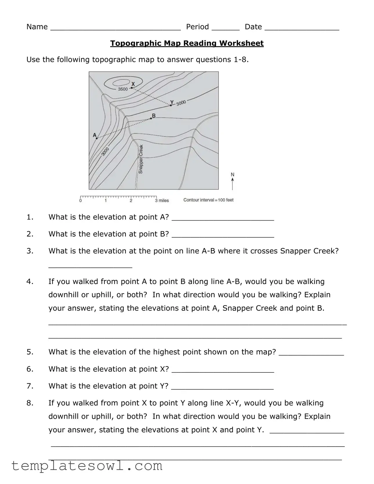
Use the following topographic map to answer questions
1.What is the elevation at point A? ______________________
2.What is the elevation at point B? ______________________
3.What is the elevation at the point on line
__________________
4.If you walked from point A to point B along line
________________________________________________________________
_______________________________________________________________
5.What is the elevation of the highest point shown on the map? ______________
6.What is the elevation at point X? ______________________
7.What is the elevation at point Y? ______________________
8.If you walked from point X to point Y along line
_______________________________________________________________
_______________________________________________________________
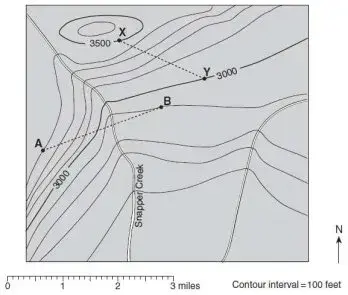
Use the following topographic map from Palo Duro Canyon State Park in west Texas to answer questions 9 - 33.
•C |
|
|
|
|
|
|
|
G• |
|
|
|
|
|
Prairie |
|
|
|
|
|
|
|
|
|
Dog |
|
|
|
1000 |
|
|
|
|
|
|
|
|
|
|
|
|
|
|
|
Town |
|
900 |
|
•B |
|
|
|
|
|
Fork |
|
|
|
|
|
|
|
|
|
•A |
|
|
|
|
|
|
|
|
|
Red |
|
|
|
|
|
|
|
|
|
|
|
|
|
|
|
|
|
Goodnight Peak |
River |
|
|
|
|
||
|
|
|
|
|
|
|
|
||
|
|
|
|
•F |
|
|
|
1000 |
|
|
|
|
|
|
|
|
|
|
|
•J |
900 |
950 |
•L |
|
|
1000 |
Brushy Butte |
•E |
|
|
|
|
|
|
|
|
|||
|
|
|
|
|
|
|
|
950 |
|
|
|
|
|
|
|
|
900 |
•K |
|
|
|
|
|
|
|
|
|
N |
|
|
|
|
|
H• |
|
|
|
|
|
|
|
|
900 |
|
•D |
|
|
|
|
|
|
|
|
|
|
|
|
|
|
Contour Interval = 10 meters
 1.0 km
9.What is the elevation of Goodnight Peak? ___________________________
10.What is the elevation of Brushy Butte? __________________________
11.What is the elevation of point A? ________________________
12.What is the elevation of point B? ________________________
13.If you walked along the creek from point A to point B, what would be the total change in elevation? __________________________ In what direction would you be walking? ______________________
14.What is the elevation of point C? ________________________
15.What is the elevation of point D? ______________________
16.What is the elevation of point E? ______________________
17.What is the elevation of point F? ______________________
18.What is the elevation of point G? ______________________
19.What is the elevation of point H? ______________________
20.What is the elevation of point J? ______________________
21.If you walked along the creek from point H to point J, what would be the total change in elevation? __________________________ In what direction would you be walking? ______________________
22.What is the lowest labeled point on the map? ___________________
23.What is the highest labeled point on the map? ___________________
24.In what direction is the river at the center of the map flowing? ____________
25.Put a small star on the map where the slope is the steepest.
26.Put a small triangle on the map where the slope is the flattest.
27.Is point K in a valley or a ridge? _____________________
28.Is point L in a valley or a ridge? _____________________
29.What is the distance from point A to point F, to the nearest tenth of a kilometer?
__________________
30.What is the distance from point H to point D, to the nearest tenth of a kilometer? __________________
31.What is the distance from point B to point E, to the nearest tenth of a kilometer? __________________
32.What is the distance from Goodnight Peak to point L, to the nearest tenth of a kilometer? __________________
33.If you could travel in time and visit the park shown on the map 100,000 years in the future, what changes do you think will have taken place to the elevations of Goodnight Peak and Brushy Butte? Explain your answer. __________________
________________________________________________________________
________________________________________________________________
________________________________________________________________
Form Characteristics
| Fact Name | Details |
|---|---|
| Purpose | The Topographic Map Reading Worksheet is designed to help students learn how to read and interpret topographic maps, focusing on elevation and terrain changes. |
| Content Scope | This worksheet includes various questions that require students to calculate elevations at specific points and analyze the slopes and directions of paths between those points. |
| Location Reference | The worksheet references a topographic map of Palo Duro Canyon State Park in Texas, providing real-world context to the exercises. |
| Educational Level | Typically used in middle or high school geography or earth science classes, this worksheet is appropriate for students learning about landforms and topography. |
Guidelines on Utilizing Topographic Map Reading Worksheet
To effectively complete the Topographic Map Reading Worksheet form, attention to detail is essential. Each section of the form requires specific information that can be gathered from the accompanying topographic map. Follow these steps carefully to ensure all necessary data is correctly recorded.
- Write your name in the designated space at the top of the form.
- Fill in the period and date fields accurately.
- Examine the topographic map and start with the first question regarding the elevation at point A. Locate point A on the map and note its elevation.
- Proceed to question 2, identifying the elevation at point B. Record this value.
- For question 3, find the point where line A-B crosses Snapper Creek and determine its elevation. Write this down.
- Question 4 requires you to analyze whether you would walk downhill, uphill, or both when going from point A to point B. Note the elevations at point A, Snapper Creek, and point B to support your explanation.
- Continue to question 5, and find the highest point on the map. Record its elevation.
- Then, identify the elevations at points X and Y for questions 6 and 7 and write those down.
- Question 8 asks about the change in elevation between points X and Y. State whether it would involve walking uphill, downhill, or both and provide the relevant elevations in your explanation.
- Move on to the section for Palo Duro Canyon State Park by referencing the map for questions 9 to 33.
- Complete questions 9 through 21 by determining the elevations of specific points and the changes in elevation when walking between designated points.
- For questions 22 and 23, find the lowest and highest labeled points on the map and record these findings.
- Question 24 involves determining the direction of the river in the center of the map. Indicate this direction in your response.
- Draw a small star where the slope is the steepest and a small triangle where the slope is the flattest, as instructed in questions 25 and 26.
- Questions 27 and 28 ask about the geography of points K and L—specifically whether they are located in valleys or ridges. Provide your answers accordingly.
- Measure and record the distances between specified points as detailed in questions 29 to 32, rounding to the nearest tenth of a kilometer.
- Finally, for question 33, speculate on the changes you believe will occur in the future regarding the elevations of Goodnight Peak and Brushy Butte, explaining your reasoning.
What You Should Know About This Form
What is the purpose of the Topographic Map Reading Worksheet?
The Topographic Map Reading Worksheet is designed to enhance understanding of topographic maps. It engages students in identifying elevations, interpreting contour lines, and analyzing changes in terrain. By answering the questions, students practice essential map reading skills, which are crucial for fields like geography, geology, and environmental science.
How do students determine the elevation at various points on the map?
To determine the elevation at specific points, students look for contour lines on the topographic map. Each line represents a certain elevation. When a point is located between two contour lines, students can estimate its elevation based on the contour interval provided. For instance, if a line signifies an elevation of 900 meters and the next one is at 910 meters, a point halfway between these lines would likely be at around 905 meters.
What skills do students practice by using this worksheet?
Students develop several skills while completing the Topographic Map Reading Worksheet. They learn how to interpret contour lines, identify elevations, and analyze the steepness of slopes. Additionally, the worksheet encourages critical thinking through questions that ask for explanations and comparisons, fostering a deeper understanding of geographical features and the relationships between them.
What types of questions can students expect on the worksheet?
The worksheet features a variety of questions that include identifying elevations at specific points, determining the change in elevation while traveling from one point to another, and analyzing the slope's steepness. There are also questions that require students to think hypothetically about future geological changes, stimulating their imagination and understanding of natural processes over time.
How can teachers use the worksheet in a classroom setting?
Teachers can incorporate the Topographic Map Reading Worksheet into lessons on geography, earth science, or outdoor education. It can be utilized as both a teaching tool and an assessment. Teachers may choose to have students work individually or in groups, encouraging collaboration and discussion. By using this worksheet, educators can ensure that students have the foundational knowledge required for more advanced studies in related fields.
Common mistakes
Filling out the Topographic Map Reading Worksheet can be a valuable exercise for understanding geographical features, yet many individuals encounter challenges. One common mistake occurs in section 1, where individuals may misread the map or overlook critical details when determining the elevation of point A. This error can lead to fundamental misunderstandings about the topography of the area. It is essential to carefully observe contour lines and the indicated elevations on the map. A moment of extra attention can prevent confusion and ensure accurate responses.
Another frequent mistake arises in question 4. Many people fail to consider both elevation points and the contour lines when explaining their walking direction from point A to point B along line A-B. Rather than simply stating whether they would walk uphill, downhill, or both, it is crucial to provide a thoughtful explanation. Highlighting specific elevations at point A, Snapper Creek, and point B will not only improve their understanding but also enhance the overall completeness of their answer.
In section 2, questions 19 and 21 deal with changes in elevation while walking along a creek from points H to J and A to B, respectively. A common error here is not calculating the total change in elevation accurately. Some students may misinterpret the contour intervals or neglect to subtract the lower elevation from the higher one. To avoid such misunderstandings, it helps to write down the steps of the calculation. Doing so can clear up confusion and provide a precise answer, which enhances learning and comprehension.
Lastly, people often overlook the importance of direction in relation to the flow of rivers and the slopes indicated on the topographic map. In questions 24 and 27, it is vital to think critically about the landscape. Misjudging the direction in which the river flows or whether a point is situated in a valley or ridge can lead to incorrect conclusions about the geography depicted. Taking a moment to visualize the flow and landscape can be immensely helpful. Such visualization not only aids in answering these questions correctly but also fosters a deeper connection with the map and its features.
Documents used along the form
The Topographic Map Reading Worksheet is an essential educational tool designed to enhance students' understanding of topographic maps. It provides a structured way for learners to engage with the elevation and landform features depicted on the map. Alongside this worksheet, several other forms and documents can support the learning process, each serving a unique purpose. Below are some of these related documents.
- Topographic Map Legend: This document explains the symbols and colors used on a topographic map. It helps students understand what different features, like rivers, roads, and forests, look like when represented in a symbolic manner.
- Contour Line Practice Worksheet: This worksheet focuses specifically on the concept of contour lines, which are critical for interpreting elevation changes on maps. It typically includes exercises that reinforce how to read and draw contour lines.
- Elevation Change Calculation Sheet: This sheet provides a framework for students to manually calculate changes in elevation between various points on a map. It reinforces mathematical concepts through geographical data.
- Field Trip Report Form: If the lesson extends to a real-world application, this form can guide students in documenting their observations during a field trip to a location with a topographic map. It encourages them to relate their learning to actual terrain.
- Map Scale Interpretation Guide: This guide offers explanations and examples of how to read map scales. Understanding scale is crucial for measuring distances and correlating them with real-world measurements effectively.
- Topographic Map Analysis Rubric: Instructors often use this rubric to evaluate students' completed worksheets or projects. It outlines the criteria for grading, helping students understand what aspects of the assignment are most important.
By utilizing these documents in conjunction with the Topographic Map Reading Worksheet, educators can create a comprehensive learning experience that enhances students' geographical literacy and critical thinking skills. Each of these tools plays a crucial role in fostering a deeper appreciation for the complexities of our landscapes.
Similar forms
The Topographic Map Reading Worksheet form is similar to several other types of documents used in education and field studies. Each serves a unique purpose while sharing common elements in structure and function. Here are four documents that are akin to the Topographic Map Reading Worksheet:
- Geographical Information System (GIS) Analysis Worksheet: This document involves analyzing spatial data on maps. Like the Topographic Map Reading Worksheet, it requires users to interpret elevation and terrain features based on graphical representations.
- Field Mapping Worksheet: Students use this form to note observations while conducting fieldwork. Similar to the Topographic Map Reading Worksheet, it encourages drawing conclusions from visual information presented in a mapped format.
- Landscape Analysis Report: This report examines various landscape features, including elevation changes and geographic formations. It parallels the Topographic Map Reading Worksheet in how it prompts users to engage with topographic features methodically.
- Environmental Assessment Form: Used to evaluate environmental conditions, this form may ask for geographical data and elevations, much like the Topographic Map Reading Worksheet, ensuring a comprehensive understanding of the land being studied.
Dos and Don'ts
When completing the Topographic Map Reading Worksheet, there are several important practices to follow to ensure accuracy and clarity. Here is a helpful list of things you should and shouldn't do:
- Do read each question carefully before answering.
- Do use a pencil for your answers, allowing for easy corrections if necessary.
- Do label specific points on the map accurately, using clear symbols as instructed.
- Do include elevation units (meters) when noting elevations.
- Don't rush through the questions; take your time to ensure understanding.
- Don't make any assumptions not supported by the map. Base answers on the information provided.
- Don't leave any questions blank; attempt to answer all of them to the best of your ability.
- Don't use permanent markers that could damage the map; stick to pencil and erase if necessary.
Misconceptions
Here are six common misconceptions about the Topographic Map Reading Worksheet form, along with clarifications to help better understand its purpose and functionality.
- All Questions Are About Measurements Only: While many questions focus on elevation, they also encourage students to think critically about geographical features, walking paths, and their implications on the landscape.
- The Worksheet is Only for Individual Work: Although it's designed for individual learning, teachers often use it in group settings. Collaboration can enhance understanding as students discuss their findings and reasoning.
- Only Advanced Students Should Use It: The worksheet is suitable for a wide range of skill levels. It can serve as an introduction to topographic maps for beginners while still challenging more advanced students.
- All Questions Require Advanced Knowledge: Many questions are straightforward, focusing simply on reading elevation markers or locating points, making it accessible for students with varying levels of expertise.
- It’s Just a Test of Memorization: The worksheet promotes comprehension over memorization. Students actively engage with the map, requiring them to analyze and interpret data rather than just recall facts.
- The Worksheet Is Outdated: The map provided references a location with geological and geographical significance, ensuring that it remains relevant and engaging for learners today.
Key takeaways
Filling out and using the Topographic Map Reading Worksheet can enhance one's understanding of landscape features and elevations. Here are ten key takeaways to keep in mind:
- Understanding the purpose of the worksheet is essential. It aims to assess your ability to read and interpret topographic maps.
- The elevation at specific points on the map is crucial. Pay close attention to the contour lines, as these indicate elevation changes.
- To answer questions about walking along certain lines, compare the elevations at the points mentioned. This will help you determine if you are walking uphill or downhill.
- Consider the direction of features like rivers and creeks. Their flow can indicate the elevation gradient in the surrounding areas.
- Using a ruler or a scale may assist in determining distances accurately between points on the map.
- Each contour interval represents an equal change in elevation. Understanding this helps in interpreting the steepness of slopes.
- Remember to use terminology accurately when describing the terrain. Words like “ridge” and “valley” have specific meanings in topography.
- Illustrating the steepest and flattest areas on the map will reinforce your understanding of the landscape’s physical features.
- Speculating about future changes can encourage critical thinking. Consider how environmental factors might alter the landscape over time.
- Finally, approach the worksheet systematically. Tackle each question methodically to avoid confusion and ensure all details are accounted for.
Browse Other Templates
Specialized Loan Servicing Foreclosure Process - Stay informed about your options through this communication channel.
Disclosure Form - Buyers are advised to verify the functional state of household appliances listed in the disclosure.